 HUNTSVILLE-The National Weather Service for The Tennessee Valley has issued a Serve Weather Alert for the area….The enhanced risk for severe storms has been expanded east and now includes almost all of northern Alabama and southern Middle Tennessee. Thunderstorms will form along a strong cold front and move into NW Alabama around 6pm. The line will move into northcentral Alabama near between 9pm to midnight and into NE Alabama between midnight to 2am. Damaging winds and tornadoes remain the primary threats with a lower threat for marginally severe hail.
There is potential for a few strong to severe thunderstorms to form this afternoon but confidence in these forming is low. The threats would again be damaging winds and tornadoes.
We will keep you updated if anything changes in the timing or the potential impacts from any of these storms.- U.S. National Weather Service, Huntsville
“A STRONG COLD FRONT WILL BRING THE CHANCE OF STRONG TO SEVERE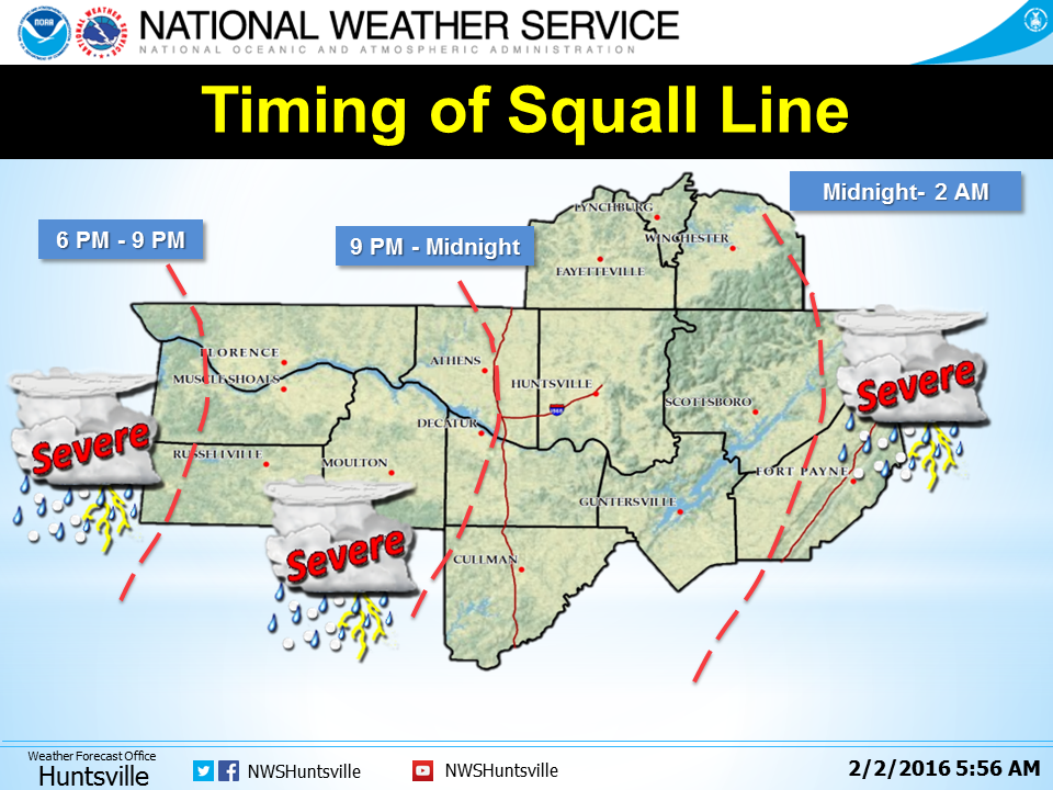
THUNDERSTORMS BEGINNING BY LATE THIS AFTERNOON OVER NORTHWEST
ALABAMA AND THEN SPREADING ACROSS THE REST OF THE TENNESSEE VALLEY
BY THIS EVENING AND DURING THE OVERNIGHT HOURS. DAMAGING WIND
GUSTS…LARGE HAIL AND A FEW TORNADOES WILL BE POSSIBLE. THE COLD
FRONT WILL EVENTUALLY SLOW DOWN AS IT MOVES INTO NORTHEAST ALABAMA BY
LATE TONIGHT…WITH HEAVY RAINFALL AND LOCALIZED FLOODING BEING A
POSSIBILITY. THE THREAT OF SEVERE WEATHER WILL TAPER OFF BY EARLY
WEDNESDAY MORNING AS THE COLD FRONT MOVES EAST OF THE AREA.
OTHERWISE…SOUTHWEST WINDS OUTSIDE OF STORMS WILL INCREASE AND GUST
TO AROUND 35 MPH AHEAD OF THE COLD FRONT…ESPECIALLY IN THE HIGHER
ELEVATIONS BY THIS AFTERNOON. A WIND ADVISORY WILL BE IN EFFECT FOR
THE AREA FROM NOON TODAY INTO EARLY WEDNESDAY MORNING.”
