
It may sound surprising, but it’s true: Atlanta, located in the heart of the Southern state of Georgia, is closer to Canada than it is to sunny Miami, Florida. The city sits at a latitude of approximately 33.7 degrees north. As the crow flies, downtown Atlanta is about 555 miles from the Canadian border at its southernmost point, and around 605 miles from downtown Miami.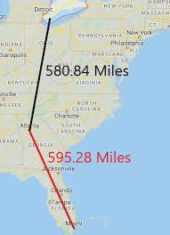
This counterintuitive fact is all due to what we can call, in layman’s terms, sticky-outy bits. If you take a look at a map of North America, you’ll see that the U.S.-Canada border dips surprisingly far south in the Great Lakes region, down through Toronto and farther south to Detroit. And most of Florida occupies another sticky-outy bit, the long peninsula between the Gulf of Mexico and the Atlantic Ocean — with Miami located near the southernmost point of the state.
Many people don’t quite realize how far south Canada stretches or how far south Miami is compared to other U.S. cities. But that doesn’t mean it’s faster to drive to Canada than to Miami from Atlanta. By car, Atlanta to Windsor, Ontario, is about 701 miles and takes roughly 12 hours. Atlanta to Miami, on the other hand, is around 660 miles and takes about 10 to 11 hours to drive.
Media Release/InterestingFacts
