 TENNESSEE VALLEY-Last outlook from U.S. National Weather Service concerning the chance for severe weather in the Tennessee Valley:
“Severe weather may begin as early as tomorrow afternoon with Isolated Thunderstorms moving through the area. The latest timing for the onset of storms from US National Weather Service Huntsville Alabama.
Note: This timing may change depending upon the front. Monitor US National Weather Service Huntsville Alabama and local media outlets for updates. Plan accordingly for tomorrow evening and tomorrow night.
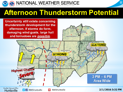
Strong to severe thunderstorms are expected from
Tuesday afternoon into the overnight hours.
• Discrete supercells may develop ahead of the squall line
in the afternoon over northwest Alabama.
• Threat of damaging winds, quarter size hail, and
tornadoes, especially from Huntsville west to the
Mississippi border.
• The timing of the line and impacts are still uncertain
and further refinement will likely continue.
• Outside of thunderstorms, breezy conditions will
persist from Tuesday afternoon through Wednesday
morning, with winds 20 to 25 mph and gusts to 35 mph”
