
449

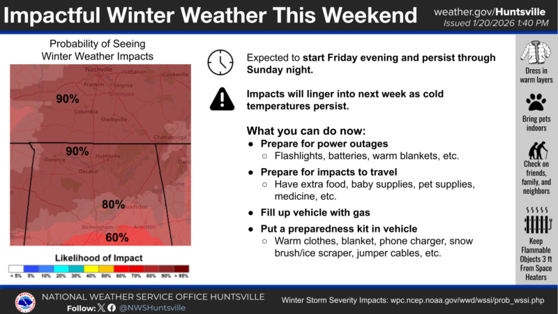
TENNESSEE VALLEY-Light rain will push into the area today and continue through Friday morning. Rain changing to a wintry mix will return to the area late Friday into Friday evening and continue over the weekend. A Winter Storm Watch is in effect from 6 PM Friday through 6 PM Sunday.
Mixed wintry precipitation could occur of at least 2 to 3 inches of snow/sleet or over one quarter of an inch of ice. Locally higher amounts possible.
Winter Weather Advisory From National Weather Service
.WINTER STORM WATCH IN EFFECT FROM FRIDAY EVENING THROUGH SUNDAY
AFTERNOON...

* WHAT...Moderate to heavy accumulations of snow, sleet, or ice are
  expected Friday night through Saturday night. Snow and sleet
  accumulations of at least 2 to 3 inches. Ice accumulations above
  one quarter of an inch. Locally higher amounts possible.

* WHERE...Portions of north central, northeast, and northwest
  Alabama and southern middle Tennessee.

* WHEN...From Friday evening through Sunday afternoon.

* IMPACTS...Expect power outages and tree damage due to ice
  accumulations. Travel could be impossible.

PRECAUTIONARY/PREPAREDNESS ACTIONS...

Persons should delay all travel if possible. If travel is absolutely
necessary, drive with extreme caution and be prepared for sudden
changes in visibility. Leave plenty of room between you and the
motorist ahead of you, and allow extra time to reach your
destination. Avoid sudden braking or acceleration, and be especially
cautious on hills or when making turns. Make sure your car is
winterized and in good working order.

Persons should consider delaying all travel. If travel is absolutely
necessary, drive with extreme caution. Consider taking a winter
storm kit along with you, including such items as tire chains,
booster cables, flashlight, shovel, blankets and extra clothing.
Also take water, a first aid kit, and anything else that would help
you survive in case you become stranded.
