
840


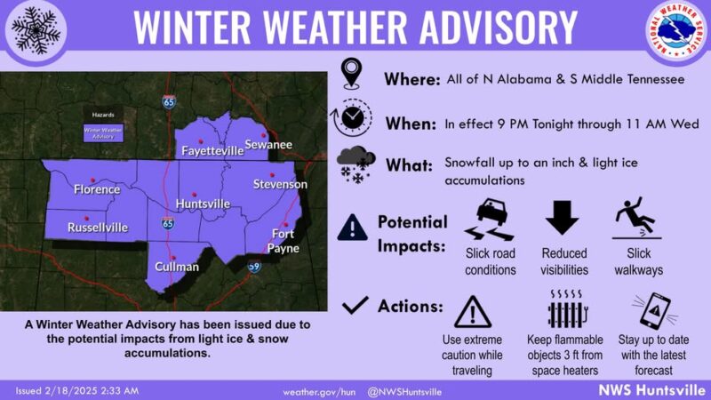
TENNESSEE VALLEY-A Winter Weather Advisory has been issued by the National Weather Service in Huntsville, AL, from 9 PM tonight until 11 AM CST Wednesday, February 19.
Mixed precipitation is expected, with snow accumulations up to one inch and a light glaze of ice.
Affected areas include portions of north-central, northeast, and northwest Alabama, as well as southern middle Tennessee.
The advisory is in effect from 9 PM tonight to 11 AM Wednesday.
Tonight
Rain and snow showers likely before 2am, then snow showers. Low around 26. Wind chill values between 19 and 24. Northeast wind 5 to 10 mph, with gusts as high as 20 mph. Chance of precipitation is 90%. New snow accumulation of less than a half inch possible.
Wednesday
A 20 percent chance of snow showers before 7am. Mostly cloudy, with a high near 35. Wind chill values between 17 and 27. North wind around 10 mph, with gusts as high as 20 mph.
Wednesday Night
Mostly cloudy, with a low around 15. Wind chill values between 4 and 9. North northwest wind around 10 mph, with gusts as high as 20 mph.
Slippery road conditions are expected, which could affect the Wednesday morning commute.
This advisor includes the following areas: Lauderdale-Colbert-Franklin AL-Lawrence-Limestone-Madison-Morgan-
Marshall-Jackson-DeKalb-Cullman-Moore-Lincoln-Franklin TN-Including the cities of Sewanee, Scottsboro, Muscle Shoals, Fayetteville, Arab, Town Creek, Decherd, Sheffield, Red Bay, Lynchburg, Cullman, Estill Springs, Moulton, Rainsville, Albertville, Cowan, Florence, Guntersville, Athens, Winchester, Russellville, Fort Payne, Huntsville, Decatur, Tuscumbia, and Boaz.
Marshall-Jackson-DeKalb-Cullman-Moore-Lincoln-Franklin TN-Including the cities of Sewanee, Scottsboro, Muscle Shoals, Fayetteville, Arab, Town Creek, Decherd, Sheffield, Red Bay, Lynchburg, Cullman, Estill Springs, Moulton, Rainsville, Albertville, Cowan, Florence, Guntersville, Athens, Winchester, Russellville, Fort Payne, Huntsville, Decatur, Tuscumbia, and Boaz.
