
58

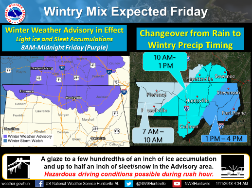
TENNESSEE VALLEY-Wintry weather is BACK! A Winter Weather Advisory has been issued for parts of North Alabama and South Middle Tennessee for a mix of ice/sleet/snow access on Friday, January 12 with highest amounts of accumulation in South Middle Tennessee Rain overnight will transition to wintry precip on Friday. The morning commute will be messy.
Winter Weather Advisory
URGENT - WINTER WEATHER MESSAGE
National Weather Service Huntsville AL
342 AM CST Thu Jan 11 2018

Counties included in The Advisory:
Lauderdale-Limestone-Madison-Jackson-Moore-Lincoln-Franklin TN-
Including the cities of Florence, Athens, Huntsville, Scottsboro,
Lynchburg, Fayetteville, Winchester, Sewanee, Decherd,
Estill Springs, and Cowan
342 AM CST Thu Jan 11 2018

...WINTER WEATHER ADVISORY IN EFFECT FROM 8 AM FRIDAY TO MIDNIGHT
CST FRIDAY NIGHT...

* WHAT...A mix of freezing rain, sleet and snow expected. The ice
  will result in difficult travel conditions, including during the
  morning commute on Friday. Total snow and sleet accumulations
  around one half an inch and ice accumulations of a trace to
  around one tenth of an inch are expected.

* WHERE...Lincoln, Moore and Franklin Counties in Tennessee.
  Lauderdale, Limestone, Madison and Jackson Counties in Alabama.

* WHEN...From 8 AM Friday to midnight CST Friday night.

* ADDITIONAL DETAILS...Changeover from rain to wintry
  precipitation will occur from west to east Friday morning to
  Friday afternoon and end as light snow late Friday night into
  Saturday morning.

PRECAUTIONARY/PREPAREDNESS ACTIONS...

A Winter Weather Advisory means that periods of snow, sleet or
freezing rain will cause travel difficulties. Be prepared for
slippery roads and limited visibilities, and use caution while
driving. The latest road conditions for the state you are calling
from can be obtained by calling 5 1 1.


For more information from the National Weather Service visit
http://weather.gov/hun
...WINTER WEATHER ADVISORY IN EFFECT FROM 8 AM FRIDAY TO MIDNIGHT
CST FRIDAY NIGHT...
* WHAT...A mix of freezing rain, sleet and snow expected. The ice
will result in difficult travel conditions, including during the
morning commute on Friday. Total snow and sleet accumulations
around one half an inch and ice accumulations of a trace to
around one tenth of an inch are expected.
* WHERE...Lincoln, Moore and Franklin Counties in Tennessee.
Lauderdale, Limestone, Madison and Jackson Counties in Alabama.
* WHEN...From 8 AM Friday to midnight CST Friday night.
* ADDITIONAL DETAILS...Changeover from rain to wintry
precipitation will occur from west to east Friday morning to
Friday afternoon and end as light snow late Friday night into
Saturday morning.
PRECAUTIONARY/PREPAREDNESS ACTIONS...
A Winter Weather Advisory means that periods of snow, sleet or
freezing rain will cause travel difficulties. Be prepared for
slippery roads and limited visibilities, and use caution while
driving. The latest road conditions for the state you are calling
from can be obtained by calling 5 1 1.
For more information from the National Weather Service visit
http://weather.gov/hun
 ...WINTER WEATHER ADVISORY IN EFFECT FROM 8 AM FRIDAY TO MIDNIGHT
CST FRIDAY NIGHT...
* WHAT...A mix of freezing rain, sleet and snow expected. The ice
will result in difficult travel conditions, including during the
morning commute on Friday. Total snow and sleet accumulations
around one half an inch and ice accumulations of a trace to
around one tenth of an inch are expected.
* WHERE...Lincoln, Moore and Franklin Counties in Tennessee.
Lauderdale, Limestone, Madison and Jackson Counties in Alabama.
* WHEN...From 8 AM Friday to midnight CST Friday night.
* ADDITIONAL DETAILS...Changeover from rain to wintry
precipitation will occur from west to east Friday morning to
Friday afternoon and end as light snow late Friday night into
Saturday morning.
PRECAUTIONARY/PREPAREDNESS ACTIONS...
A Winter Weather Advisory means that periods of snow, sleet or
freezing rain will cause travel difficulties. Be prepared for
slippery roads and limited visibilities, and use caution while
driving. The latest road conditions for the state you are calling
from can be obtained by calling 5 1 1.
For more information from the National Weather Service visit
...WINTER WEATHER ADVISORY IN EFFECT FROM 8 AM FRIDAY TO MIDNIGHT
CST FRIDAY NIGHT...
* WHAT...A mix of freezing rain, sleet and snow expected. The ice
will result in difficult travel conditions, including during the
morning commute on Friday. Total snow and sleet accumulations
around one half an inch and ice accumulations of a trace to
around one tenth of an inch are expected.
* WHERE...Lincoln, Moore and Franklin Counties in Tennessee.
Lauderdale, Limestone, Madison and Jackson Counties in Alabama.
* WHEN...From 8 AM Friday to midnight CST Friday night.
* ADDITIONAL DETAILS...Changeover from rain to wintry
precipitation will occur from west to east Friday morning to
Friday afternoon and end as light snow late Friday night into
Saturday morning.
PRECAUTIONARY/PREPAREDNESS ACTIONS...
A Winter Weather Advisory means that periods of snow, sleet or
freezing rain will cause travel difficulties. Be prepared for
slippery roads and limited visibilities, and use caution while
driving. The latest road conditions for the state you are calling
from can be obtained by calling 5 1 1.
For more information from the National Weather Service visit
