
56

 TENNESSEE VALLEY-A Winter Storm Warning has been issued for the entire Tennessee Valley from 6pm Tonight to 6am Tuesday. Significant ice accumulations from Sunday evening through Monday night will translate into very hazardous travel conditions due to ice & sleet covered roadways. Limit travel if at all possible late Sunday through Monday night and have your Winter Emergency Kit ready ( Water, Food, Flashlight, First aid kit, Extra batteries, masks, Cell phone charged up, Sleeping bags or warm blankets and a manual can opener.
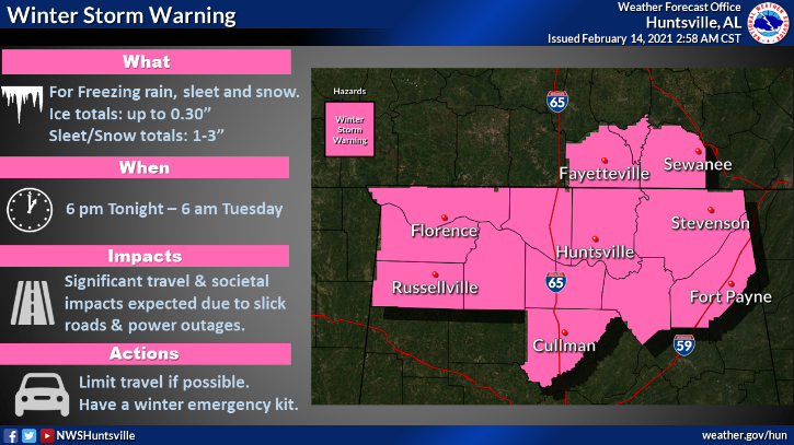
WINTER STORM WARNING IN EFFECT FROM 6 PM THIS EVENING TO 6 AM
CST TUESDAY
Freezing rain will develop this evening into tonight and
mix with sleet and snow Monday into Monday night. Total sleet
and snow accumulations of 1 to 3 inches. Ice accumulations of
up to two tenths of an inch. Areas affected Lauderdale, Colbert, Franklin AL, Lawrence
and Limestone counties. In Tennessee, Moore, Lincoln and Franklin TN counties.

Some power outages and tree damage will be possible
due to the ice. Hazardous travel conditions should be expected
by the Monday morning commute and will likely be exceedingly
difficult to near impossible by Monday afternoon into evening.

Power outages will be possible due to the
expected ice accumulations, which in some rural areas could last
for a few days. The combination of bitter cold temperatures
Monday night into Tuesday will make conditions particularly
hazardous for those that do lose power. Residents should be
prepared and have an emergency supply kit ready in the event of
a long duration power outage.
