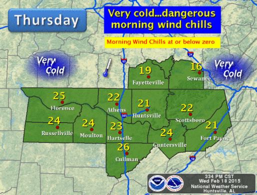
 TENNESSEE VALLEY-Dangerous wind chills in the morning with values at or below zero. Temperatures start in the single digits Thursday morning and only warm from the teens to low/mid 20s. This is close to 30 degrees below normal for this time of year.
Dress in layers, keep hands and feet warm, and wear a hat. To avoid hypothermia do not stay outdoors for prolonged amounts of time.
Bring your pets indoors or provide a safe warm place for them during this cold snap. Be a goon neighbor, call on the elderly in your neighborhood and check on those who you suspect may not have adequate heat or shelter.
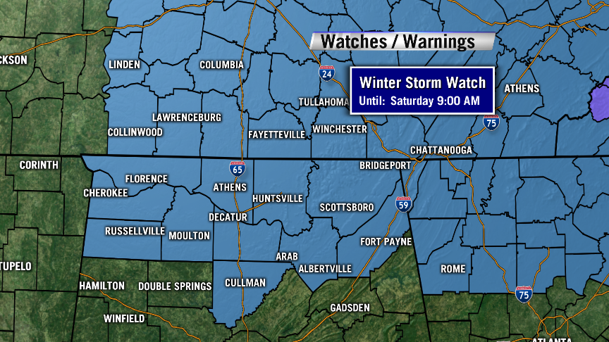
Several weather advisories have been issued by the National Weather Service through Saturday, February 21:
WIND CHILL ADVISORY REMAINS IN EFFECT FROM 7 PM THIS EVENING TO 11 AM CST THURSDAY… … WINTER STORM WATCH IN EFFECT FROM FRIDAY AFTERNOON THROUGH SATURDAY MORNING…
THE NATIONAL WEATHER SERVICE IN HUNTSVILLE HAS ISSUED A WINTER STORM WATCH… WHICH IS IN EFFECT FROM FRIDAY AFTERNOON THROUGH SATURDAY MORNING. THE WIND CHILL ADVISORY REMAINS IN EFFECT FROM 7 PM THIS EVENING TO 11 AM CST THURSDAY.
* TIMING AND AREAS AFFECTED… ALL OF NORTHERN ALABAMA. THE WIND CHILL ADVISORY IS IN EFFECT FROM THIS EVENING THROUGH THURSDAY MORNING. THE WINTER STORM WATCH IS IN EFFECT FROM FRIDAY AFTERNOON THROUGH SATURDAY MORNING.
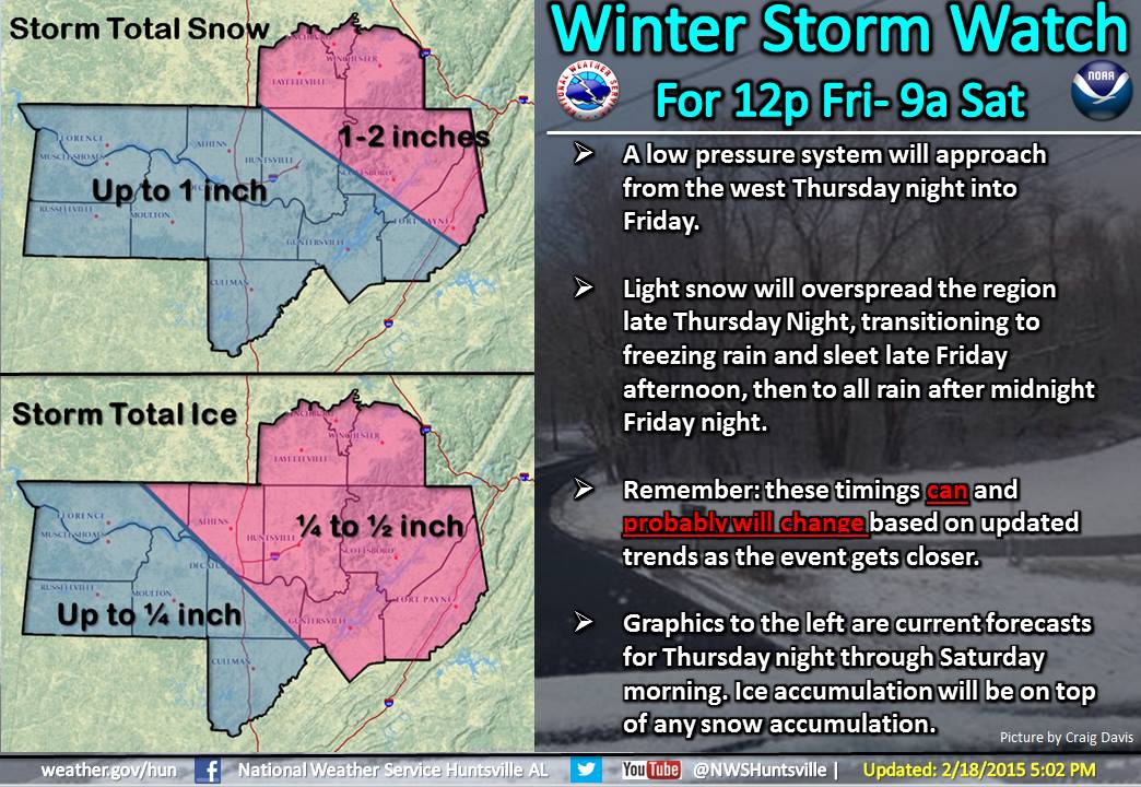
* IMPACTS… WIND CHILLS THIS LOW WILL CAUSE EXPOSED FLESH TO BECOME SUSCEPTIBLE TO FROSTBITE IN A MATTER OF MINUTES. MIXED WINTRY PRECIPITATION COULD POTENTIALLY CAUSE SIGNIFICANT TRAVEL PROBLEMS FRIDAY AFTERNOON AND SATURDAY MORNING.
* ACCUMULATIONS… UP TO TWO INCHES OF SNOW AND OR SLEET… AND UP TO A QUARTER INCH OF ICE.
* WIND CHILL VALUES… 0 DEGREES TO 10 BELOW ZERO.
PRECAUTIONARY/PREPAREDNESS ACTIONS…
A WIND CHILL ADVISORY MEANS THAT VERY COLD AIR AND STRONG WINDS WILL COMBINE TO GENERATE LOW WIND CHILLS. THIS WILL RESULT IN FROST BITE AND LEAD TO HYPOTHERMIA IF PRECAUTIONS ARE NOT TAKEN. IF YOU MUST VENTURE OUTDOORS… MAKE SURE YOU WEAR A HAT AND GLOVES.
A WINTER STORM WATCH MEANS THERE IS A POTENTIAL FOR SIGNIFICANT SNOW… SLEET… OR ICE ACCUMULATIONS THAT MAY IMPACT TRAVEL. CONTINUE TO MONITOR THE LATEST FORECASTS.
More Information
… ARCTIC AIR WILL SEND WIND CHILLS PLUNGING TONIGHT… … APPROACHING STORM SYSTEM TO BRING A GOOD CHANCE OF HAZARDOUS WINTER WEATHER FRIDAY AND SATURDAY…
