
44

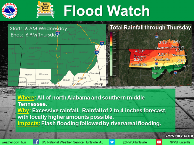
TENNESSEE VALLEY-The National Weather Service has issued a Flood Watch for the area for Wednesday, February 28 and Thursday, March 1.
Rainfall amounts of 2-4 inches are expected, with locally higher amounts. This will result in excessive runoff, possible flash flooding, followed by areal and river flooding. Stay tuned for later updates and possible warnings from the National Weather Service
"FLOOD WATCH REMAINS IN EFFECT FROM WEDNESDAY MORNING THROUGH
THURSDAY AFTERNOON...

The Flood Watch continues for

* Portions of Alabama and southern middle Tennessee, including
  the following areas, in Alabama, Colbert, Cullman, De Kalb,
  Franklin AL, Jackson, Lauderdale, Lawrence, Limestone,
  Madison, Marshall, and Morgan. In southern middle Tennessee,
  Franklin TN, Lincoln, and Moore.

* From Wednesday morning through Thursday afternoon

* Multiple waves of moderate to heavy rainfall will impact the
  area late tonight through Thursday afternoon as a warm front
  moves north through the area, followed by a cold front on
  Thursday. 2 to 4 inches of rainfall is expected, with locally
  higher amounts up to 5 inches possible, especially where
  training of thunderstorms occur.

* With area rivers and streams already running high combined
  with the saturated soils, it will not take much rain for areal
  and river flooding of low lying areas and some roadways to
  occur. Do not drive through water that is covering a road.

PRECAUTIONARY/PREPAREDNESS ACTIONS...

A Flood Watch means there is a potential for flooding based on
current forecasts.

You should monitor later forecasts and be alert for possible
Flood Warnings. Those living in areas prone to flooding should be
prepared to take action should flooding develop."
